Mijas es un encantador municipio en la provincia de Málaga, ubicado a lo largo de la soleada Costa del Sol en el sur de España. Conocida por sus casas encaladas, impresionantes vistas costeras y rica herencia cultural, Mijas se ha convertido en un destino popular...
Map of Spain – Your complete guide to understanding Spain
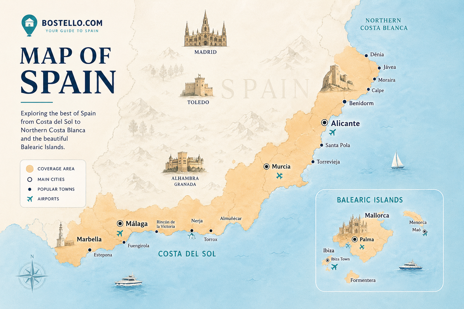
A detailed Map of Spain is one of the most powerful tools when planning a move, investment, or holiday in Spain. Whether you’re searching for coastal properties, vibrant cities, or peaceful inland regions, a clear Spain city map helps you understand where everything is located.
At Bostello, we connect maps with real estate opportunities—so you can easily navigate Spain and find the perfect place to live or invest.
Map of Spain – Overview of Regions
A standard map with Spain shows that the country is divided into 17 autonomous regions, each offering a unique lifestyle, climate, and property market.
Some of the most popular regions include:
- Costa del Sol (Andalusia)
- Costa Blanca (Valencia region)
- Costa Brava (Catalonia)
- Balearic Islands (Mallorca, Ibiza)
- Canary Islands
A Map of Spain and regions helps you quickly understand the differences between coastal hotspots, urban hubs, and rural areas.
Spanish coasts map – Understanding Spain’s Coastline
A Spanish coasts map is essential for anyone looking to buy property near the sea. Spain offers more than 5,000 km of coastline, with each area having its own character:
- Costa del Sol – Sunny, international, and vibrant
- Costa Blanca – Affordable and popular among international buyers
- Costa Brava – Rugged beauty and proximity to Barcelona
- Costa de la Luz – Authentic and less crowded
Using a Map of Spain and coasts, you can easily compare locations and decide where your ideal lifestyle fits best.
Spain city map – Major Cities Explained
Our detailed Spain city map highlights the most important cities:
- Madrid – The capital and financial center
- Barcelona – Culture, beach, and innovation
- Valencia – A perfect mix of city and coastline
- Málaga – A fast-growing hotspot on the Costa del Sol
A city of Spain map is especially useful when comparing commuting distances, lifestyle, and access to amenities.
👉 Explore city living:
Map of western Spain – Hidden Opportunities
A Map of western Spain reveals lesser-known regions that offer great value and authenticity:
- Extremadura – Affordable and untouched
- Castilla y León – Rich in history and vineyards
- Galicia – Green landscapes and dramatic coastline
A Map of Spain and inland regions helps uncover these hidden gems, often overlooked by international buyers.
Map of Spain and airports – Travel Made Easy
One of the most important, but often overlooked factors is accessibility. A Map of Spain and airports helps you understand how easy it is to travel to your destination.
Key international airports include:
- Málaga Airport (AGP) – Costa del Sol
- Alicante Airport (ALC) – Costa Blanca
- Barcelona El Prat (BCN)
- Madrid Barajas (MAD)
When analyzing a Map of Spain, always consider proximity to airports for convenience and long-term value.
Map of Spain and property hotspots
Our modern Map of Spain highlights where demand is highest, what we call property hotspots at bostello:
- Marbella & Estepona
- Torrevieja & Orihuela Costa
- Palma de Mallorca
- Barcelona coastline
These areas combine strong lifestyle appeal with solid investment potential.
👉 Discover hotspots:
How to use a Map of Spain to find the right property
A Map of Spain is more than just geography – it’s a decision-making tool. Here’s how to use it effectively:
- Identify coastal vs inland areas
- Compare proximity to airports
- Explore cities using a Spain city map
- Analyze regions with a Map of Spain and regions
- Compare property prices across Spain
- Explore some option and buy property in Spain
At Bostello, we simplify this process by combining map data with real estate listings.
Map of Spain and Renfe – Understanding Travel by Train
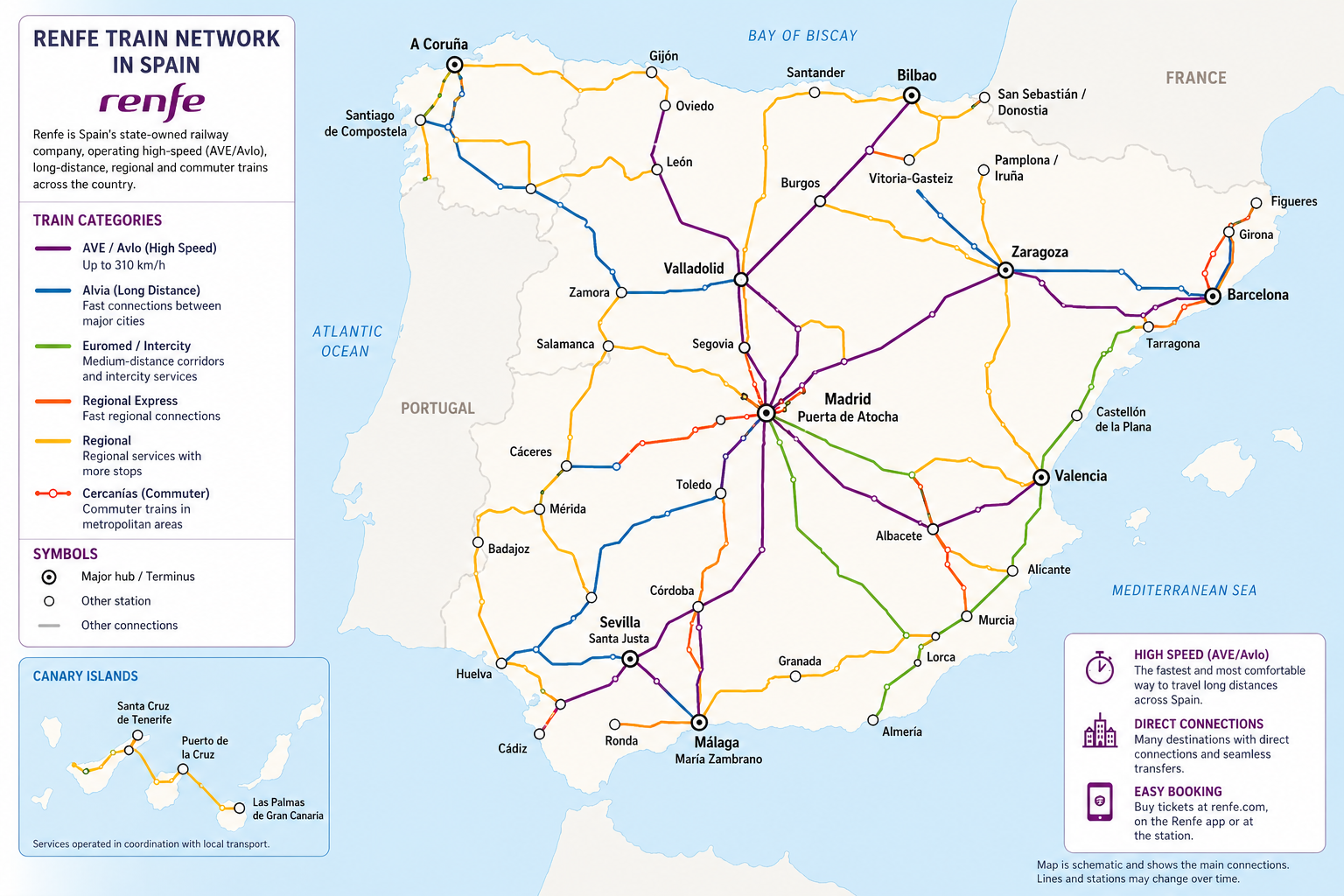
When analyzing a Map of Spain, it’s important to understand how the country is connected and this is where the Renfe train system plays a key role. Renfe is Spain’s national railway network, linking major cities like Madrid, Barcelona, Valencia, and Málaga through high-speed AVE trains.
By looking at a Map of Spain and transport routes, you’ll quickly see how efficiently you can travel across the country – often faster than flying when you factor in airport time. A detailed Spain city map combined with Renfe routes helps you evaluate commuting options, weekend travel, and accessibility between regions. For property buyers, proximity to a Renfe station can significantly increase both convenience and long-term value, especially in well-connected areas along the coast and between major urban hubs.
Why a Map of Spain is essential
A well-understood Map of Spain helps you:
- Navigate the country with confidence
- Identify the best regions and cities
- Plan travel and logistics
- Discover investment opportunities
Whether you’re exploring a Spanish coasts map, a city map Spain, or a Map of western Spain, the map is always your starting point.
Ready to explore Spain?
Start browsing properties across the country using our interactive Map of Spain and find your dream property in Spain.
FAQ – Map of Spain
Where is Madrid on the Map of Spain?
Madrid sits in the center, making it an ideal hub for day trips across the plateau.
What are the main regions I should know?
Andalusia (south), Catalonia and Valencia (east), the northern “Green Spain,” central Castiles, plus the Balearic and Canary Islands.
Which coast is best for beaches?
For warm Mediterranean waters, look east and south (Costa Blanca, Costa del Sol). For wild scenery and surf, check the northern Atlantic coast.
Where are Spain’s highest mountains?
Sierra Nevada in Andalusia (mainland) and volcanic Teide in Tenerife (Canaries).
Is the Map of Spain helpful for rail travel?
Yes! major AVE lines radiate from Madrid to Barcelona, Valencia, Seville, Málaga, Zaragoza and beyond.